Expedition Photos, Maps, and Charts
HOME PAGE
Code Glossary & Basics
EVENTS OF 2021
2020 Events
MARS & ALIEN DISCLOSURE
2019 Events
2018, 2017 & 2016 Events
2015 and 2014 Events
2013, 2012 & 2011 Events
Contents 2: Code&Ark Issues
Contents 3B: Other Mars Science
Contents 3A: MarsCorrect
Contents 3C: Mars Codes
Contents 4: UFOs
Contents 5: President Trump
Contents 6: Obama
Contents 7: Israel
Contents 8: Time Travel
Contents 9: People (alphabetically)
Contents 10 - Generals
RON DESANTIS IN 2024
BIDEN'S CODE PORTRAIT
President - Enemy of State?
Biden & our Government betray us. Why?
ILLUMINATI
America Fallen 2
America Fallen 1, Gen. Milley & ET
American is Fallen 2
America Fallen
Letter to CERN & UK MOD
BIDEN LOSES AFGHAN WAR
Afghan Interpreter OBIDULAH AMIN
Biden Out of Control
General John Hyten
Senator Paul vs. Fauci
China Wants Japan Nuked
Reversing Time
REVIEW OF UAP ASSESSMENT
WHITE RAGE FOR GENERAL MILLEY
Milley & Critical Race Theory
Admiral Gilday's Treason
Salla's View of Ceres
Forbes, Code say China War Coming
Generals and Signals from Future
Generals and Admirals Condemn Biden
Tompkins & Sexy Aliens
Beirut Explosion & Date
DeSantis for President?
Giuliani Home Raid
Cryptocurrency Market Factors
Weak Biden & Taiwan's Fate
Muslim Noah Green Attacks Capitol
Poison Vaccine & Wuhan
Video: Alien Embryo in Meterorite
Ebrahimi/Sawicki Publication
Ebrahimi: The forest through the trees
China Slams Biden on Race
Mars Perserverance Credibility
Tony Fauci & Wuhan
Governor CUOMO Scandals
Video: Trump 4th Reich Enemies
Trump Torah Rumors
TIC TAC UFO
Annual Mars Report Update
Deep State & Biden's Reich
Remarks about January 6, 2021
Don Lemon
Biden Takes Oath 7 Shevat
Not at the Inauguration
Secret Space Program Economics
Why Are Durham and Barr Silent?
Decreasing fertility - A plot?
Ebrahimi, 4th Reich & Road Ahead
Ebrahimi & the Chinese Press
General Tata vs. the 4th Reich
UFO Hacker
Know Your Enemy: the 2020 Election
Facebook, Twitter & 4th Reich
Biden Cheated
Biden's Health
Joe Biden's Surrender Values
Clark McClelland Saga
Obama, Malcolm X & Hitler
TR-3B UFO
Mars Base
Trump Gets COVID-19
COVID-19 & THE 4TH REICH
Enemy of the State?
Ruth Ginsburg Dies
Durham Hides FBI results past election
HITLER & THE 4TH REICH
Hitler, Antarctic & UFOs
Biden Teleprompter
Rittenhouse, Pelosi & Civil War
2020 Asteroid Threat
Kamala, Reparations & Health Care
Alien Infiltration
Communist Obama, Creepy Biden
Chloroquine, Moderna, Vaccine&Meteorites 3/26/2020
Warning to China &Wickramasinghe
2020 Time Odyssey
Statues and Statutes
Bolton's Breakdown
Yoho Curses AOC
ANTIFA
De Blasio Out?
Star Wars: Air Force vs. Space Force
Finally...OBAMAGATE!
No Further Explanation
Chinese War Preview
Trump takes Chloroquine
Source of Covid-19 Radio Interview
Alien Embryo
EBRAHIMI E-Mails
Ebrahimi Attachments
PowerPoint Ebrahimi to Wuhan
Source of Ebrahimi Meteorites
Wickramasinghe & Wuhan 4/19/20
Boris Johnson & Wuhan 4/8/20
Wuhan Patient Zero 4/7/20
Ebrahimi Meteorite Virus? 4/1/2020
24,000 Dead by 1st of Nisan 3/27/2020
Remdesivir
Wuhan, Martial law & Milley 3/19/20
Israeli Vaccine for Wuhan 3/19/20
Meteorite & Kirkland 3/18/20
Wuhan Virus 3/29/20
Wuhan Virus & Stocks 3/2/20
Bloomberg & M. Obama
Pelosi Rips Speech
Ebrahimi rock
Secession from the Union
A DEAD AYATOLLAH?
Ukraine Airliner Downed
Threat to White House&Pentagon
GENERAL SOLEIMANI KILLED
SOLEIMANI UPDATE
Biblical Nanotechnology
Gen. Milley & Ocasio Cortez
Militias, Trump & Civil War
Leaker Vindman
Yovanovitch & Hunter Biden
Abu Al Ata Assassinated
WHISTLE BLOWER
Trump Tax Returns
John Durham vs. Deep State
General Milley Fighting ETs & Hyrbids
Netanyahu Mandate Fate
Code Politics and Art
Growing Civil War Talk
Trump Impeached?
Saudi Oil War
Beto O'Rourke & Guns
Bolton Report Card
Trump: Disloyal Jews
Hurricane Dorian
Epstein's Clinton Portrait
Michelle Obama in 2020
Epstein Death
Epstein& Clinton
Mueller & Fusion GPS
Video Games & Shootings
DNI Coats out Ratcliffe in & out
Martian Contamination
Omar: Impeach Trump
Einstein's dog
NY Blackout, Iran&Korea
EMP Attack & Transformers
Trump & Kim at DMZ
Iran War 2019?
MIRROR UNIVERSE.
Gold Asteroid Mission
Philly Oil Fire
John Paul 2 in WW2
Mexican Wall
Port Canaveral Threat?
N. Korean Ship Seized
Liberman brings down Netanyahu
Enemy Nadler
Future Barr Indictments
Barr vs. Obama&Clinton
List of my TV & Radio Shows
Huachuca tease
Sri Lanka Attack
Fall of Maduro?
Mueller Corruption
Israeli Election 2019
Israeli Moon Crash
ET & Time Control
Biden's Groping
Peter BUTTIGIEG
MARS LIVES!
Mike Cohen & Nuc War
Golan Heights & Gaza
Divided Goverment & UFOs?
Trump on Socialism
Ilhan Omar
Kamala Harris & Healthcare
Trump grounds Air Pelosi
National Emergency & The Wall
Warren 2020: Candidate or Lunatic?
MotherF Rashida Tlaib
Syrian Withdrawal
SecDef/General Mattis Resigns
Gen. Flynn & Judge Sullivan
Iran's General Mansouri
CIVIL WAR AHEAD
July 2018 Radio Interview
2017 Torah Codes Skype Interview
Macron & Merkel
Tijuana & MS13 Border
Angela Merkel
Mars InSight Lands
2 Crimes: Mail Bomber vs. Attack on Synogogue
Plastic Threat
Avenatti Arrested
U.S. Demographics
Khashoggi Murder
Algae/Oxygen on Mars?
Volcanic Eruption on Mars?
Jeff Flake, Obama&Mueller
Collins Confirms Kananaugh
Crazy Democrats
Brett Kavanaugh
Bill Cosby - Really Guilty?
Kurzweil & the Singularity
Radiant Face of Moses
Pope & Sex Abuse
Paul Manifort Trial
John McCain - Ever Abducted?
FBI raids Trump's lawyer
Ellison, Hitler, Jews&Insanity
Trump Not Establishment
Colonize Mars
Feinstein's spy driver
Secret Funding for Space?
Huachuca madness
Trump, Putin, Helsinki & ET
Lake on Mars
Rosenstein Impeached?
Maxine Waters
SPACE FORCE
Mars Dust Storms & Bacteria
Mars Correct - Connecting the Dots
Mars MAVEN
Jeff Sessions
Singapore Summit
Trump Nobel Prize
Bourdain Suicide
No Gay Wedding Cake
Helo to Mars
Inspector General
JERUSALEM EMBASSY
Kim frees 3
Quantum Entanglement
Iran's General Soleimani
Project Amad
Giuliani Mistake
ATOMIC TRAIN
Creator Decoder
Armageddon Assad Update
Gaza border fight
Kim surrenders nukes?
John Bolton
Stormy Daniels
Tillerson fired. Pompeo hired.
Brookhaven Natl' Lab
Tachyon Time
Climbing Mt. Sharp
Time Machine and Ezekiel
Shooter Nick Cruz
Tachyons & Wormholes
Arrow of Time
Steven Hawking
Mexico Wall
Uranium One
Trump calls Dems Treasonous
Deep State & Vatican
Eagles win Superbowl
Trump, Haiti & Truth
Peter Strzok & Comey
New California
Falcon Heavy Tesla&Mars
Popadopoulos Arrest
God from Future?
False Nuc Alarm
Andrew McCabe
Korean Olympics war threat
Jerusalem is capital
Bir El Abd, Daesh & Ark
Texas Church Massacre
Morgenthau for Vietnam
Schumer brought Sayfullo
Deep State
Level 3
Redirect Asteroid to North Korea
Vegas Security Guard
Steven Paddock
Robert E. Lee & Slavery
Korea, Guam & Atomic Holocaust
Kim, Obama & Iran Nukes
Korean Propaganda
FUTURE WARNING
China Economic War
Transgenders & Military
Trump Jr. & Russian Veselnitskaya
Otto Warmbier
Steve Scalise Shot
Trump & Paris Accord
Biden & Romney
Known terrorist & London Bridge
Code Names Manchester Bomber
Comey&Schumer Coup Attempt
CFR BrzezinskI
Mueller & Impeachment Attempt
Syrian Crematorium
TRUMP FIRES COMEY
President Ping & Korean War
MOABs against N. Korea
Obama Nobel
China-Korea Japan War
Korean Atomic War
Trump Attacks Putin&Assad
Kananpaa & Bogus Mars Weather
Rice&Obama spy on Trump
Ryan's Health care fails
Islam's Judas
Westminster Attack
THAAD missile shield
Obama wiretaps Trump
Enemy News
Trump, Musk & Mars
Fort Huachuca
Trump, Enemy Media & Insomnia
TRAPPIST-1 Solar System
General H. R. McMaster
Tom Price & ObamaCare Repeal
Australia& Obama attack America
Mike Pompeo at CIA
Jared Kushner
Manning Sentenced
CIA's John Brennan
Ft. Lauderdale ISIS Airport Shooter
DNC Hacker: Putin or Netanyahu
Alien Virus & Politics
Trump: Embassy to Jerusalem
Netanyahu: Israel out of U.N.?
Close the U.N.
Karlov assassination
Carrie Fisher as Leah
Aleppo, Syria
Obama Birth
Trump Administration
General Mattis: SECDEF?
Trump picks Viola For Army
Obama's Gay Sec. Army
Tilllerson as Secretary of State
Frozen sea on Mars
Trump&Romney
General Flynn
Trump & Mexico
Trump&Prejudice
Trump Elected?
TRUMP PICKS PENCE
Steve Bannon
Trump & Kelly Bimbo
Obama, Clinton, Trump & Mental Illness
Donald Trump in 2016?
Trump&Obama
Blumenthal & Birthers
Oct 5 TV interview
SpaceX Failure - Sabotage?
Clinton Stroke?
Kaepernick Treason
ZIKA
Weiner Saga
Obama kills flag pledge?
N.Y. Iman Murdered
Debbie Shultz fired as predicted
Ali Sonboli - Munich killer
Clinton EMail & FBI Comey
Micah Johnson: Cop Killer
Senator Perdue Obama prayer
HAIL BRITANNIA!
Omar Mateen & Obama
Muhammad Ali
RADIO INTERVIEW 5/8/2016
Mars Powerpoint
Katie Couric Lies
2016 Election
Romney tries convention theft
PRINCE DEATH
Hot Mars Info
UFO Hypnosis
Alien President
Obama - Reptilian Alien?
Obama in Cuba
Time Experiment
Garland&Obama
Targeting Iran
Scalia Murder?
Bloomberg in 2016
Martian Life seen by MSL?
Christian Values & Election
Oldest Person
Running water on Mars
Mars Weather on 682 days
Contents: People
Nimr A-Nimr Beheaded
Space X Lands
Podkletnov update
Netanyahu Kills Samir Kuntar
Pope: No Jewish Conversion
Russian Beheaded
Turkey downs Russian Jet
Pollard Matrices
Jihadi John & Paris
Metrojet Crash
James Webb in 2016: Surprise?
Boehner Out, Ryan In
Destruction of Rome
Nuke War Date?
Bin Laden&O'Neill
TIANJIN EXPLOSION
Huckabee & Kim Davis
NASA Achilles Heel
World War 3 Date
Gays & World War
Excommunicate 3 Justices
No Strategy Obama
Lincoln Chafee in 2016
Bob Jindal in 2016?
John Kasich in 2016?
Ben Carson 2016?
Lindsey Graham in 2016
George Pataki in 2016?
Bernie Sanders in 2016?
Martin O'Malley in 2016?
Vatican recognizes Palestine
Carly Fiorina in 2016?
Clinton Foundation
Korean Defense Minister Shot
Freddie Gray Riot
USS Roosevelt to Yemen
Obama Surrender
Gilbert Levin found Mars Life
Valerie Jarrett
Bergdahl &Obama Impeachment?
Palestinian State?
Obama Traitor & Iran
Boehner invites Netanyahu
Netanyahu Says NO to Obama
Netanyahu&UN
NETANYAHU
Satanic Obama's enemies
Anti-Semite Obama
Podesta UFO Disclosure
UFO Disclosure
Pelosi and Netanyahu
Pharaoh Obama
Jordanian Pilot
LT Kateasbeh
Japanese beheaded
Livni vs. Netanyahu
Air Asia Crash
2015 DATES
Jan. 1, 2015
Charlie Hebdo
Communist Obama & Cuba
Ferguson Verdict
1st Ferguson Riot
Eric Holder
Dr. Brandenburg: Nuke on Mars
Moshe Feiglin - future Prime Minister?
ISIS, Kassig, & Obama
Executive Action & Impeachment
O'NEILL SHOOTS BIN LADEN
Elon Musk & Sabotage
Gaza Buffer Zone
Islam attacks Ottawa
Kim Jong Un
Comet Siding-Spring
Tom Duncan Ebola to US
India & Mars
Ebola Obama
Khorasan in Syria
Alton Nolen Beheads
Scotland Votes
NY Nuke Nightmare
Pistorius Trial
Is Obama Our Enemy?
Is Obama Really Hamas?
Cameron vs. Obama
Israel&ISIS
Sotloff Beheaded
Foley Beheaded
Obama & Mind Reading Computer
Logistics & Gaza War
Joan Rivers
Robin Williams
Voices from the Cosmos
Birthday UFO
Gaza 2014 War
Gaza Children
Netanyahu launches Protective Edge at Gaza
Contents 7: Science &Tech
DEAD SEA SCROLL
CODES ON TV
Roffman Code Radio Show
Talmud&Names
Malaysia Flight 17
Al- Maliki & Defeat in Iraq
Why Cantor Lost
Jay Carney
Repulsine Drive
Potter UFO 1
Michael Sam
Boko Haram
Donald Sterling
Ranch War?
Malaysia Airlines
Air France
Malaysia Pilot Zaharie Shaw
Ukraine, Russia & War
President Snowden?
Kerry Messianic
Snake Salvation Death
Belarus & ObamaCare
Mars Rock Mystery
Pot President
Roffman Mars Radio Show
Justin Bieber
Minimum Wage
Duck Dynasty
Bush in 2016
Clinton 2016
Biden in 2016
Cruz in 2016
Christie in 2016?
Ryan in 2016
Rand Paul 2016
Romney 2016
Rubio 2016
Walker in 2016
Santorum 2016
Perry in 2016
Cuomo in 2016
Warren 2016
Satanic Obama
Cure to Aging?
Polygamy
China Crisis
Iran-Nuke-Deal
2014 Dates Encoded
911:Atomic-Iran
Keep-your-plan?
Sebelius&Obama
Nelson Mandela
Comet-Ison-Fear
End of America
Janet Yellen
Kenya-Mall-Terror
PUTIN OP-ED
Putin, Obama, Assad & Enemies
Israeli Intel vs. Assad
Mubarak Freed?
Mubarak Death?
McCain & Morsi
MAJOR HASAN
Bill O'Reilly
Fear of Obama
Zimmerman Free
Flood on Mars
Politics alters Mars weather
Egypt's ElBaradei
Army Suicide
Mullah Omar
TWA FLIGHT 800
Gay Scouting?
Tornado Chasers
Swiss against Kosher food
ALLAH AKBAR & Mickey Mouse
Jodo Arias
Mars Cover-up & Obama
N. Korea & Boston
Where is God?
Obama-Assad
Bombers Found
GUANTANAMO
Nuke Korea
Hagel&Korea
Kim Jong Un
Warship Sunk
Korea Attack
Erich VonDaniken
Brain Mapping
JC Stomp
Mars Hoax
Knives on Jets
Obama&Israel
New Pope
Cardinal Mahoney
Chavez&Obama
Pope Resigns
Rick Perry
2018 Mars mission crew
Slideshows for Codes & Mars
Asteroid 2012da14
School Shooting
Fordo Iran Nuke Hit?
Dr. Afrida
2013 Dates Encoded
Lance Armstrong
Hitler Escaped?
Mars Coverup
Doomsday
Benghazi&Rice
Arafat Polonium
Election&Code Lessons
Biased News
Babylon, America &Obama
2012 Election
Stevens Murder
Rubio, Gays & Catchism
World War 3
Identity Chips
Obama=Nuke War
Arab Riots
Mars One Way
Batman Shooter
Assad Update
Iran Overdue
Fast&Furious
Time & Boson
Prometheus
Zionist Threat?
Breitbart Death
New Party
Nuclear Talks
Flame Virus
Stuxnet Virus
Obama&Gays
Chaplain Woes
Attack Iran?
Ending Muslim Terror
USS Cole
Reagan&UFOs
2012 & The End of Days
End of Days
Romney vs. Obama
Obama vs. Court
Hunger Games
Obama Open Mic
Threat Analysis
Master of Fate
Nuke Iran
Foreign Aid
Russian Veto
Panetta&War
Iranian Threat
Atomic Threat
Brewer's Finger
Mitt Romney
War in Hormuz
WAR in 2012
EMP Attack
Malcolm X & Obama
Nuke Murder
Concordia Sinks
Israel to Moon
Rocket Sabotage
2012 Republicans
Atom. Holocaust
Missile Base Attack
Isfahan Attack
Iran is Gog
Rabbi Levin
Altering Time
Iran War Plan
Qaddafi Death
Kaddafi Execution
Solyndra Loan
DEFINE ELS
Aldrin&Obama
Obama Alias
EXODUS ROUTE
Pakistan&Osama
Scott Jones&ET
BinLaden Dead
2012 ELECTION
Obama's Failure
UFO Teleportation
Gravitics&Time
Baptism Annulled (Spiritual Custody)
Define ELS-Map
Alien DNA
No Alien gods!
Winds of Mars
2012 Supernova?
Obama History
Dual Citizen
Obama's School
Barry Soetoro
251.565 MAPS
ARK HISTORY
Expedition Pics
ELS MAP 1
ELS Map 2
ELS MAP 3
ELS MAP 4
ELS MAP 5
ELS MAP 11
ELS MAP 12
ELS MAP 13
ELS MAP 14
ELS MAP 15
ELS MAP 16
EXPEDITIONS
ETHIOPIA&ARK
Tanis&the Ark
Who's a Jew?
Tree of Life
2012 Dates Encoded
Ron Wyatt & Saudi Sinai
Vatican&Hitler
Vatican Rule
Jack Lu: The Finance Jew
Act of God & Election
Ukraine Riots
Rosetta Comet Landing
Boston Marathon
Sue Bradley
OBAMACARE
Shutdown
Secession Vote?
Obama hoax?
NewYork Curse
Major Hassan
Hitler Youth
Code Hypothesis
United States
Ariel Sharon
Netanyahu Wins, Yair Lapid 2nd
McChrystal Fired
Obama Security
Apartheid Israel?
Obama, Muslim King of Sodom
Obama Brother
Sgt Bob Bales
Korean Execution
Mars Lies
Ishmael's Birth
Sochi Terror
Gas Masks in Israel
Korans Burned
New Gaza War
Gaza Jabari Hit
Assad's Missiles
Chris Dorner
Piers Morgan: Amend Bible?
Khalid Mansour
8-27-2012 GOP Convention
Egypt's Election
Attack via Azerbaijan
Philadelphi Rt.
Paul Ryan
Whitney Houston
Nazarene-wife
Asteroid Toutatis
Mayan Doomsday
Holdings Book
Ahmadinejad in Space
Korean Rocket
Coach Sandusky
Armstrong&Moon
Armada vs. Iran
Qaddaffi son killed
Romney&Bain
Trump's wife abd election problems
Mormon Concerns
London Olympics
Photos&Maps 2
Zubrin & Mars
7/28/12 Threats?
Mars Stonewall
Weather Goof by Mars Rover
Remote Viewing
Comet Lovejoy
Space Shuttle
Odd Shortsale
Japan Tsunami
Fukushima&End
Meltdown
Plutonium&H2O
UFO Abduction
Shutdown Deal
WikiLeaks
1st Debate No Teleprompter
Rodney King
China in Space?
Alien Hybrids?
Bob Salas UFO
MSL Sky Color
Mars Sky Color
Ashima/MIT&Mars
End of NASA
Brain-Reading
Brokow vs. Gingrich
Newt Gingrich
Santorum&Gays
Roberts Vote
Ron Paul
Cain Withdraws
Jeb Bush 2012
Assad's Wife
French Election
Basketball Court
Hamid Karzai
Terror in France
Mofaz&Netanyahu
BeerSheba Attack
George Soros
Shalit Release
Steve Jobs
Social Security
Barney Frank
Michele Bachman
Mineral Quake
9-11-2011
Lennon&Imagine
Irene Flood
Joplin Tornado
Casey Anthony
Jeff Savage
Eilat Attack
Renfroe UFO
Mt. Sinai Pics
Rocket Defense
Haiti Earthquake
Giffords shot
Impeach Obama?
Obama Loss
Qaddaffi&Obama
Don't ask/tell?
Internet Dangers
Past Presidents
Jon Huntsman
Bush Memoirs
Bin Laden
New Civil War?
Rahm Emanuel
Roman Rahm
Mayor Rahm
Antimatter
Planet Kepler22b
Atomic Iran
Peace Talks
Abu Mazen
U.S. Israel Rift
Israeli ship-raid
Iran Chicken
Iran&Suez Canal
Mousavvi
Top Kill Fails
Pakistan Flood
Halliburton&Oil
Mars Monolith
Potter UFO 2
End of All Life
IRS Attack
Chemical Ali
Oil Spill
Oil and Life
Airline Miracle
Christmas
Polish President
Gaza Iron Wall
Life on Mars
Ark to Mars
UFO Onion-Drive
Wormholes
Martian Life
Olympus Mons
MSL Mars Launch
H Bomb Test
Supercollider
ANTIGRAVITY
Robson&Jupiter
Onion Drive Update
NIKOLA TESLA
Armageddon Assad Holocaust
PALIN RESIGNS
613
IRAN WAR
Gaza Invasion
ZECHARIAH
Statistics
Permutation
Control Text
Obama&Islam
NASA Director
Michael Jackson
To Muslims
2008 Election
Clintons
Clinton Weds
Nuclear War?
Baal Zephon
B. Zephon&Ark
Implications
Jeremiah&Ark
Vendyl Jones
In Jerusalem?
Al-Awlaki Death
Ark Destroyed?
Titus/Rome
Knights Templar
Mt. Nebo/Ireland?
ELIYAHU RIPS
Rabbi Glazerson
Hawass&Permits
Religious Tests
Other Texts?
Mayan Calendar
Google&Privacy
Nasrallah
Judge Elena Kagan
Obama&McCain
Snooping
Skip Tables
Term Positions
RABIN MURDER
27-August-2012
Judge More (sp.)
YASIR ARAFAT
Hurricanes
Walter K. York
Romney&Netanyahu
LINKS
Roswell
Angelic Doctor
Joseph Smith
Rod Rosenstein
Transgender Michelle?
Mars SAM
Buy ARK CODE
ROFFMAN BIO
Weiner Scandal
Spiritual Custody Contents
Annulled Ch. 1
Annulled Ch. 2
Annulled Ch. 3
Annulled Ch. 4
Annulled Ch. 5
Annulled Ch. 6
Annulled Ch. 7
Annulled Ch. 8
Annulled Ch. 9
Annulled Ch10
Annulled Ch11
Annulled Ch12
Annulled Ch13
Annulled Ch14
Annulled Ch15
Annulled Ch16
Annulled Ch17
Annulled Ch18
Annulled Ch19
Annulled Ch20
Annulled Ch21
Annulled Ch22
Annulled Ch23
Epilogue
Custody press coverage
MSL Yr 5 Fall
MSL Yr 5 Summer
MSL Yr 5 SPRING
MSL Yr 4-5 Winter
MSL Yr 4 Fall
MSL Yr 4 Summer
MSL Yr 4 Spring
MSL Yr 3 Winter
MSL Yr 3 Fall
Twenty and back
MSL Yr 3 Summer
MSL Yr 3 Spring
MSL Yr 2-3 Winter
Kerry Obama Iran Hoax
Sept 4 2019 Radio Show
Ebrahimi Update
DOD-UKMOD SITREP 3 JULY 2020
R VALUES
Enemy John Kerry
DarkSide Ramsomware
BIDEN FOR HAMAS
Malaysia shoot down
Custom 3
Pelosi & Milley vs. Trump
Israel blows up Iranian missile base
Saule Omarova & Our Money
Shi Zhengli Covid Bat Woman
Steven Weil and Ethiopian Jewry
Custom 3
OCT 20 2021 RADIO INTERVIEW
Custom 3

The above photo was taken in May 2005 in the immediate vicinity (probably within 100 yards) of the suspect Ark site. However, I did not have GPS equipment with me at time, so the position was estimated based on the direction of the salt marsh (Mallahet Ugret Selima) in the background.

ABOVE CIRCLED IN RED IS APPROXIMATELY 31 DEGREES 9 MINUTES NORTH, 33 DEGRESS 4 MINUTES EAST (GOOGLE MAPS). THIS IS WHERE MY SEARCH FOR THE ARK BEGAN. THERE IS COMMERCIAL SALT EXTRACTION NEARBY, AND THE ROAD NETWORK IN THE AREA HAS RECENTLY BEEN BUILT UP.

ABOVE: CIRCLED AREA IS APPROXIMATELY 31 DEGREES 9 MINUTES NORTH, 33 DEGRESS 4 MINUTES EAST (GOOGLE MAPS). BODY OF WATER LABELED SHAMAL SINA (meaning North Sinai) IS ACTUALLY THE SALT MARSH "UGRET SELIMA." SHAMAL SINA MAY REFER TO COMPANIES EXTRACTING SALT.

ABOVE: Dark circles at the suspect Ark site. The larger circle is believed to be at the exact spot where the ELS Maps indicate the Ark should be. The physical nature of these spots in unknown..

The obstruction in the Mediterranean (at 31-16 North 33-3.5 East) may be the missing fortress of Baal Zephon (see Exodus 14:2, 14:9, and Numbers 33:7). The suspect site for the Ark of the Covenant is south of it on the El Zuqba peninsula at 31-9 North, 33-4 East.

ABOVE: Portion of the 1:100,000 Northern Sinai Qatia chart published by the Survey of Egypt in 1935 (17/35/850). The obstruction (believed by me to be Baal Zephon) at 31-16 North, 33-3.5 East was added by me based on British Admiralty Chart 56100.

ABOVE: SEASONAL VARIATION IN SALT CONTENT OF SALT MARSHES ON THE EL ZUQBA PENINSULA

ABOVE: The MacMillan Bible Atlas sees Baal Zephon as being very close to the suspect Ark site. However, they show it on land, where it has not yet been found. As sea level has increased since the fortress vanished, we should look just offshore.

THE HEBREW MAP OF THE BARDAWIL-ZUQBA AREA ABOVE WAS OBTAINED DURING MY FIRST EXPEDITION IN 1999. ON IT, THE TRANSLITERATION OF BARDAWIL INCLUDES AN EXTRA LETTER - LETTER YUD. HOWEVER, EVEN JERUSALEM HAS SPELLINGS IN THE BIBLE WITH AND WITHOUT AN EXTRA YUD. ZUQBA ON THIS MAP STARTS WITH A LETTER ZAYIN RATHER THAN A TSADAH. HOWEVER, IN TRANSLITERATIONS THESE VARIATIONS ARE ACCEPTABLE. AS IS NOTED ELSEWHERE ON THIS SITE, BAAL ZEPHON HAS TWO DIFFERENT SPELLING IN TORAH, AS DO A NUMBER OF OTHER NAMES.

ABOVE: Defense Mapping Agency of the USA, Chart 56100 of the Mediterranean Sea, Egypt, EL-ISKANDARIYA (ALEXANDRIA) TO THE SINAI, 1:300,000 scale, soundings in meters (based on British Admiralty and U.S. Charts to 1991).

ABOVE: MALLAHET EL SAFIA, SOUTH OF MALLAHET UGRET SELIMA. BODY OF WATER LABELED SHAMAL SINA (WHICH MEANS NORTH SINAI) IS ACTUALLY THE SALT MARSH "UGRET SELIMA." SHAMAL SINA MAY REFER TO COMPANIES EXTRACTING SALT.
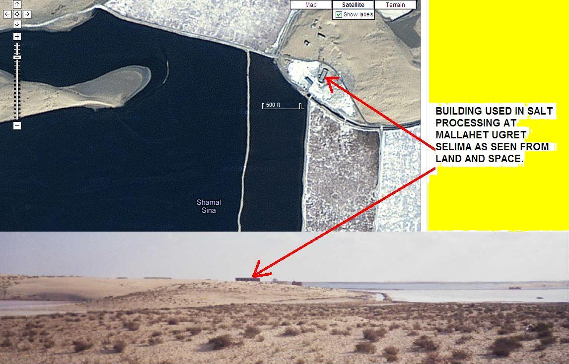
ABOVE: Bottom Photo - The Ark Site area - looking toward Ugret Selima salt marsh (in the background above) on El Zl Zuqba. Photo taken in May 2005. Top Photo - same area with the same building as seen from orbit.

ABOVE: AL QALS PENINSULA ON THE NORTHERN SIDE OF LAKE BARDAWIL
.jpg)
ABOVE; HARPER BIBLE ATLAS MAP SHOWING 2 POSSIBLE SITES FOR BAAL ZEPHON, ONE NEAR EL ZUQBA AND LAKE BARDAWIL

ABOVE: THIS TRUCK TOOK ME OVER SAND DUNES TO GET TO THE SUSPECT ARK SITE AREA. THE WATER BEHIND ME IS MALLAHET UGRET SELIMA.

Above: Northern terminus of 26 km road up from Bir El Suleman on El Zuqba Peninsula. Water at top is Lake Bardawil. Facility at terminus may be an Egyptian Coast Guard Station. Below: We tried to hire this boat skipper from port shown under his picture, but the Egyptian Coast Guard didn't want foreigners sailing around Lake Bardawil.

ABOVE: Writing ARK CODE while at sea en route to Egypt in 1999. Passage aboard the Royal Caribbean Cruise Line ship SPLENDOR THE SEAS between Miami and Spain was free for our family in exchange for three lectures onboard about my Ark Code research.

ABOVE: BOAT SKIPPER. EGYPT COAST GUARD WOULDN'T ALLOW HIM TO TAKE US TO ZUQBA FROM HARBOR SHOWN.

ABOVE: EGPYTIAN MILITARY BASE IN NW CORNER AND (ABOUT 6,500 FEET FROM IT) THE SUSPECT ARK SITE CIRCLED IN RED IN LOWER RIGHT.

ABOVE: BEDOUIN WOMAN GETTING WATER OUT OF A WELL A FEW HUNDRED FEET FROM THE SUSPECT ARK SITE.

ABOVE: To reach the suspect Ark site, turn north from Highway 30 at Bir El Suleman just east of Bir El Abd

Above: Updated chart showing a wreck 31-14 N, 33-4 E about 2 miles from the obstruction believed to be Baal Zephon. Depth soundings are in meters.

ABOVE: Pier (red circle) at 31 degrees 12 minutes North, 33 degree 2 minutes East. Small buildings or shacks in orange ellipse.

ABOVE: Another satellite image of the suspect Ark site,.
